


GPS Map Ruler-area measurement
توضیحات GPS Map Ruler-area measurement
GPS Map Ruler یک برنامه اندازه گیری نقشه است که به عنوان یک خط کش نقشه مجازی عمل می کند که می تواند برای اندازه گیری فاصله بین دو نقطه و همچنین اندازه گیری فاصله بین نقاط مختلف و اندازه گیری منطقه مورد استفاده قرار گیرد. با انتخاب چندین مکان مختلف در نقشه جیپیاس، اندازه گیری از راه دور یا منطقه را می توان به سرعت به دست آورد.
امکانات
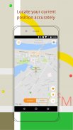
1. محل سکونت: موقعیت فعلی خود را تعیین کنید، همچنین انتخاب مکان مناسب است
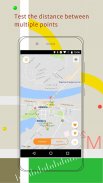
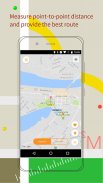
2. اندازه گیری فاصله: فاصله نقطه به نقطه را اندازه گیری کنید، هر مسیری را که می خواهید با استفاده از اندازه گیری فاصله ما انتخاب کنید
3. انتخاب نقشه: نقشه های متعدد موجود، از جمله نقشه های منظم و نقشه های ماهواره ای
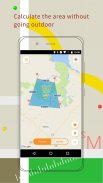
4. اندازه گیری منطقه: اندازه گیری منطقه بر روی نقشه دیجیتال بدون رفتن در فضای باز
با استفاده از GPS Map Ruler، اندازه گیری فاصله و اندازه گیری منطقه را آسان تر و سریعتر کنید تا مسافرت کنید، بیرون بروید و نظارت راحت تر
GPS Map Ruler-area measurement - اطلاعات APK
نسخه APK: 1.9.3حزمة: com.lixiangdong.mapruleآخرین نسخه GPS Map Ruler-area measurement
سایر نسخهها


 3.64
3.64


اپلیکیشنها در دسته مشابه

شاید دوست داشته باشید...


